
Hautes-Pyrénées · Winter 2025–2026
🇫🇷 France
Peyragudes
Germ / Loudenvielle
2 400 m alt. max60 km of runsSnowparkBeginner area
Book a ski pass →
🌿 Summer version →
60
km of runs
46
marked runs
18
ski lifts
2 400 m
maximum altitude
About
Peyragudes
Family resort in the heart of the Hautes-Pyrénées, between Peyresourde and Les Agudes. Contemporary architecture, ski-in/ski-out access and varied terrain between two panoramic ridges.
800 m
Vertical drop
120
Snow cannons
10 km
Snowshoeing
4
Mountain restaurants
December → April
Season 2025–2026 · 113 days
Live webcams
Peyragudes · Real-time conditions
Run breakdown
Ski area
in detail
Run details
Green runs
8
17%
Blue runs
16
35%
Red runs
17
37%
Black runs
5
11%
Ski km60 km
Min. altitude1 600 m
Max. altitude2 400 m
Vertical drop800 m
Artificial snow15 km
Avg snowfall/yr380 cm/an
1
Cable cars
3
6-seat chairlift
2
4-seat chairlift
6
Fixed chairlifts
6
T-bars & carpets
18
Total lifts
ESF Peyragudes
4
Restaurants
Activities & services
Beyond the slopes
What the resort offers
Snowparkcheck_circle
Beginner areacheck_circle
Cross-country skicancel
Snowshoeing10 km
Bike park (summer)check_circle
Bike park VTT (summer)check_circle
Hiking (summer)check_circle
Via ferrata (summer)check_circle
Zip line (summer)check_circle
Paragliding (summer)check_circle
Canyoning (summer)check_circle
location_city
Tourist office
Office de Tourisme de la Haute Vallée du Louron
Chemin de Cazalis, 65510 Loudenvielle
Website open_in_new
Maps
Skiing area maps
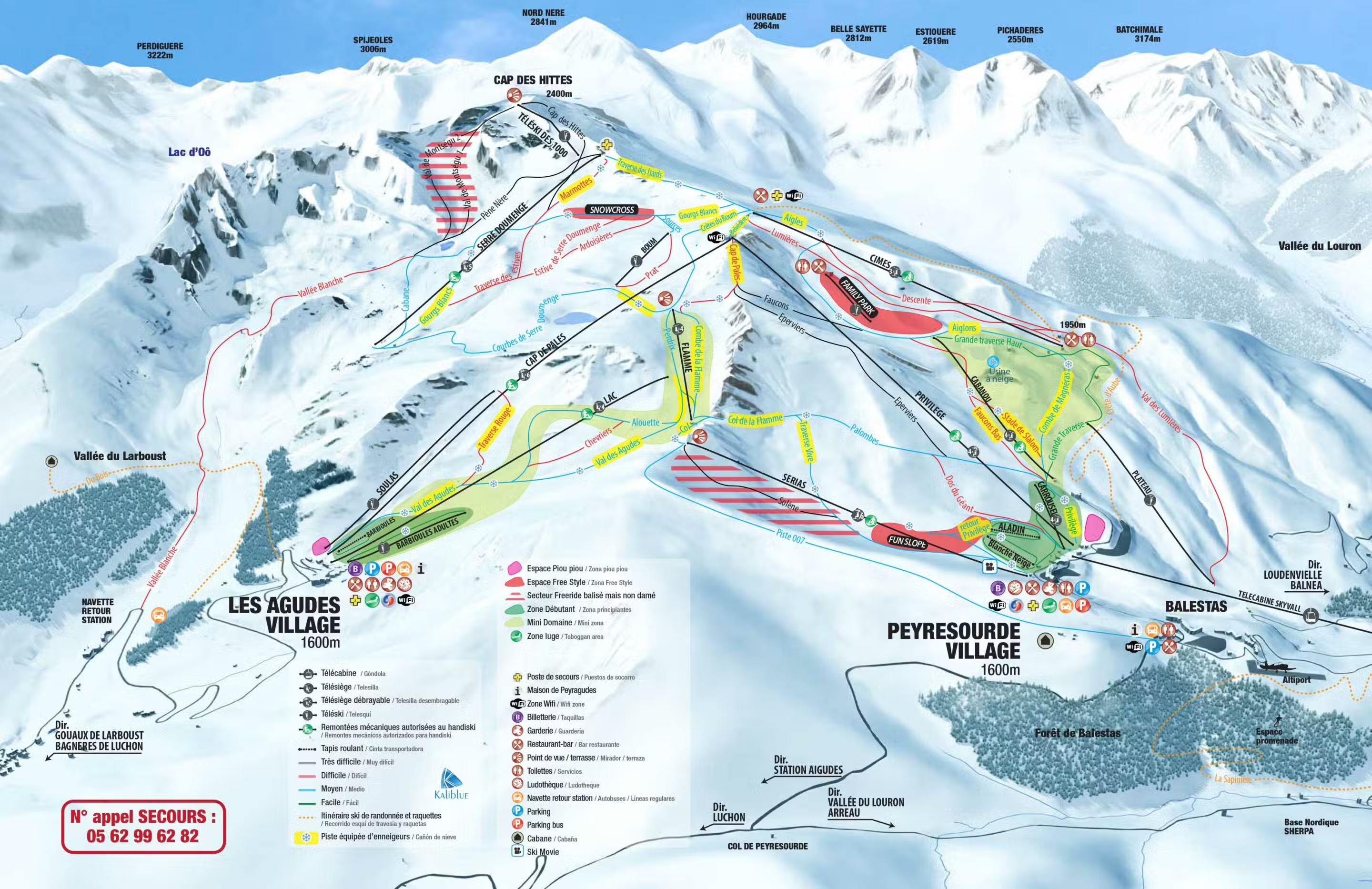
Winter piste map
Skiing area
60 km · 46 runs
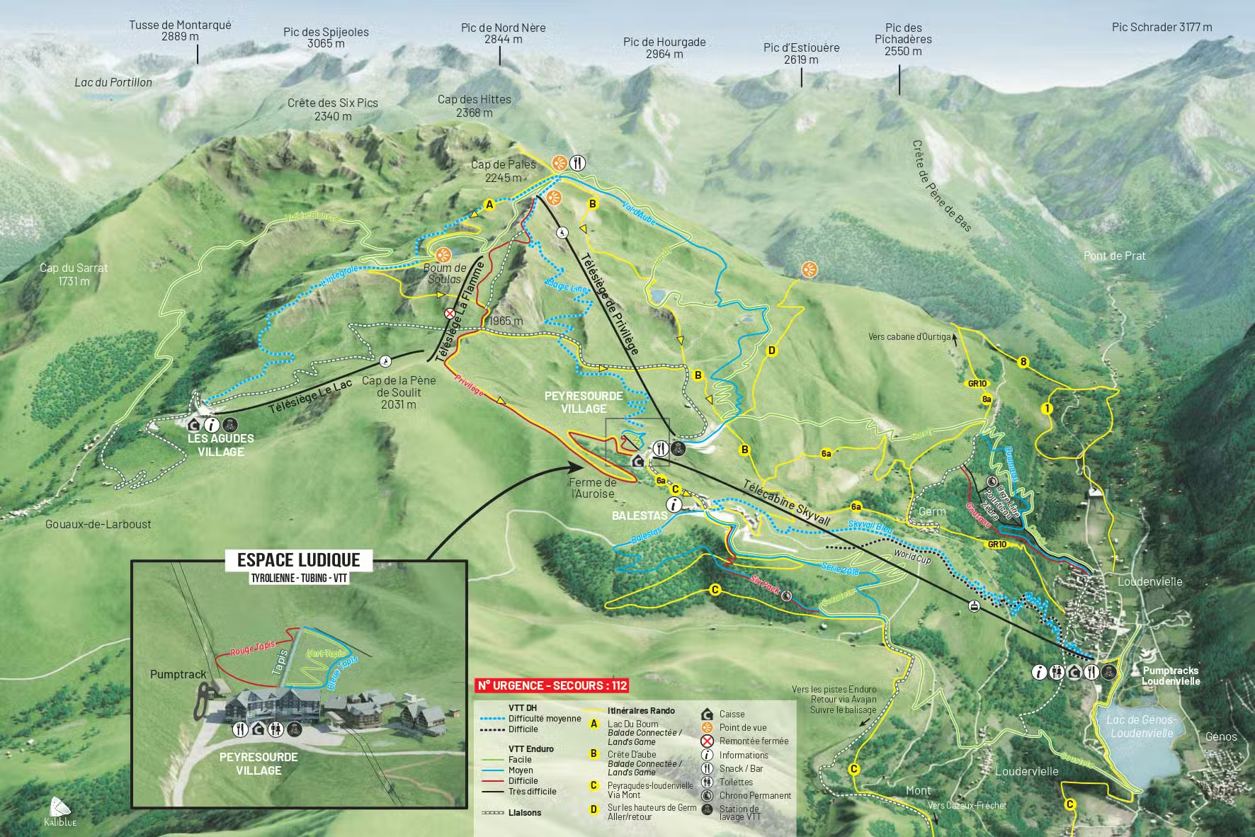
Summer MTB map
Bike Park & MTB
Descents & marked trails
Altitude
Take in the heights
Village altitude1 600 m
Min. ski altitude1 600 m
Max. ski altitude2 400 m
Total vertical800 m
Average annual snowfall380 cm
Family resort in the heart of the Hautes-Pyrénées, between Peyresourde and Les Agudes. Contemporary architecture, ski-in/ski-out access and varied terrain between two panoramic ridges.
Leaflet © OpenStreetMap, © CARTO
Live weather
+23°C
Snow depth
None
Wind
8 km/h
Practical information
Everything to plan your stay
Season 2025–2026
December → April
113 days open
Slopes hours
9h00 → 17h00
Subject to conditions
Contact
+33 5 62 99 69 99
Mountain weather
Getting there
Germ / Loudenvielle
Hautes-Pyrénées